

In the first edition of Rye News in 2014 we asked "Is Rye really at risk of flooding?" As part of our tenth anniversary year the author of that original report, Anthony Kimber (Rye Neighbourhood Plan and a former member of the Southern Region Flood and Coastal Committee), considers what has changed over the last decade.
Since 2014, four matters regularly arise in the context of flood risk: climate change; more frequent extreme rainfall events and surface water flooding; land instability and ongoing work on flood defences.
There are many other related issues such as future food and water security, pollution in rivers and of the coastline, impacts on heritage assets, impacts on business and enterprise, nature and animal activity. These are beyond the scope of this piece.
The changing climate
Greenhouse gases generated by human activity traps heat in the Earth's atmosphere but allows sunlight to pass through. This is the main cause of a 1.2°C rise in temperature since the industrial revolution (UK Climate Impacts Programme - UKCIP). Despite a UN target of keeping to a 1.5°C rise before 2025, there could be a rise of 2.5°C or 3.0°C, before it eventually levels off.
In parts of the south east, the temperature in the hottest days of the year has increased by 1°C per decade in the years 1960–2019 (Met Office).
The UK is at just the right latitude where cold polar air from the north meets warmer tropical air from the south, and it is along this boundary that the jet stream - a band of strong winds high in the atmosphere - which drive low pressure systems around the globe. Predictions are that for every degree Celsius of global warming the jet stream's winds increase by about 2%.
Higher temperatures, particularly in summer and autumn, result in more water from the oceans evaporating into the atmosphere. Warmer air holds more moisture; every 1°C rise in air temperature allows air to hold 7 percent more water vapour. When that air reaches cooler land, it condenses as rain. When the jet stream slows or stalls over a particular area, extreme rainfall can result.
The UK is getting more rain on average throughout the whole year; about 7 percent more over the past 30 years (Met Office). September 2024 was one of the wettest months in parts of England. In Sussex, weather stations recorded 154mm of rain across the month (three times the average). The mean for the whole year was around 700mm. The Met Office expects that in future, more frequent extreme rainfall events can be expected.
Sea level
Global warming also results in the thermal expansion of sea water, increased in volume by melting glaciers and ice sheets, aggravated by some land slowly sinking. There is much research on the rise of sea level, with various figures indicating the degree of rise: 21mm higher now than in 1901 (Brighton University) and 11.4cm rise between 1993 and 2022 (Southampton University). The mean rate of rise per year is from 1.8mm to 3.2 mm, but it is predicted that the rate is increasing (Brighton University).
The Environment Agency, using medium risk scenarios in its models, is anticipating a rise of up to 50cm in Rye Bay and Dungeness by 2080 and in the worst case 80cm by 2100. The agency estimates that one in six properties in England will be at risk from flooding from rivers, sea or surface water in broadly the same period. Some 1200 homes in low lying areas of Rye are deemed to be at risk now as they are dependent on flood defence structures (Environment Agency).
Holding the line
With the coastline of the south east under threat from rising sea level and named storms, there will be increased pressure on sea and tidal river defences. Since the 1953 floods, the highest risk coastal defences in the south east have been strengthened and raised to adapt to increasing risks to coastal settlements and farmland. In December 2013, at Rye Strand, a high (spring) tide lifted by a surge and onshore wind, rose to 5.1m AOD, just 0.7m below the top of flood defences.
For many years the Folkestone to Fairlight tidal defence system has had a vulnerable stretch: the 5km long Eastern Rother Tidal Wall defences (Scots Float to Rye Golf Club). This has been subject to bank erosion and damage. The current scheme will lift the bank to 5.8m AOD, to match that of the western bank.
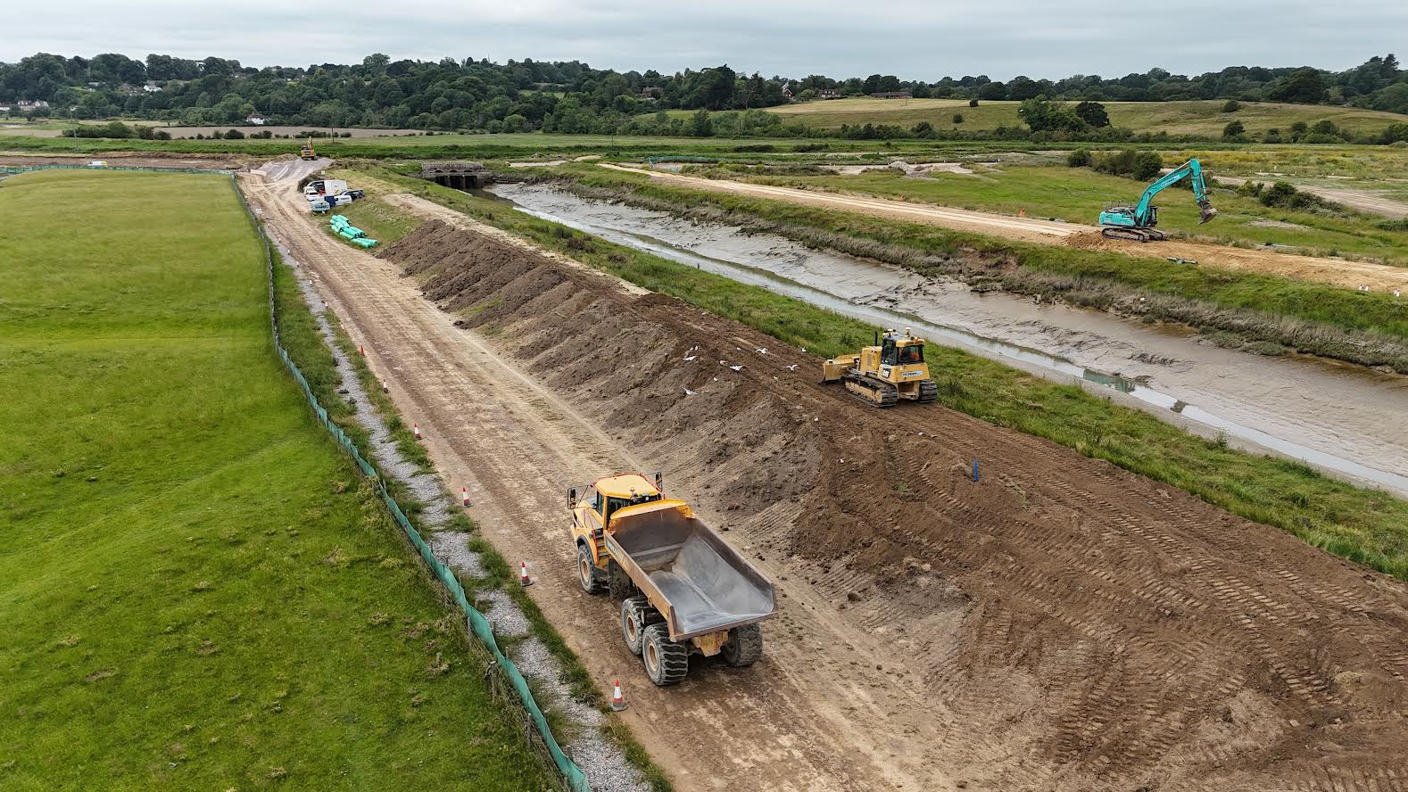
Other ongoing local work is aimed at improving the key Brede and Tillingham sluices.
Part of the investment in defences is to monitor and selectively improve areas subject to significant erosion. One such area is Fairlight to Hastings, which is at risk of cliff falls, caused by erosion.
In a lower coastline, such as Winchelsea Beach, the shingle is moved by the tide (“longshore drift”) and has to be maintained by the periodic deposition and engineering of the sea shore.
Maintenance of defences comes at a significant cost. With almost 1,200km of sea defences in the south east, difficult decisions have to be taken about the long term and costly improvements to defences. In places, where the coast is more vulnerable and less inhabited, one option is to “manage a retreat” along the lines of the proposal for Fairbourne in central Wales, which is assessed as high flood risk.
Surface water
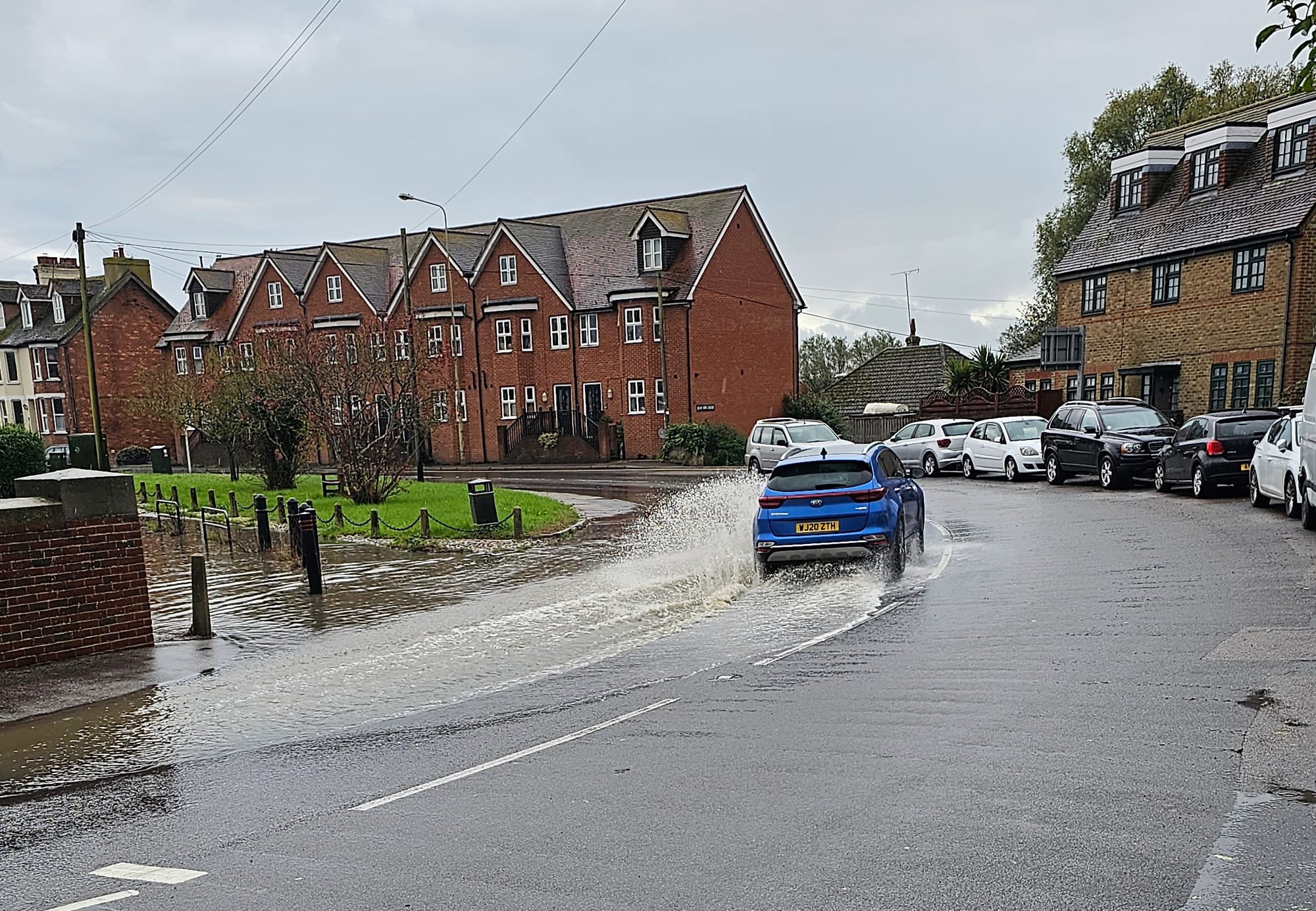
Rye is surrounded on two sides by marsh. Here groundwater levels are often high, limiting its ability to absorb quickly large quantities of rainfall. As a result, there have been incidents where property on the edge of the town has been put at risk. Within Rye, surface water flooding, some call it flash flooding, occurs when heavy rainfall overwhelms the capacity of drains and sewers. Rye has a combined sewer and rainfall runoff system, which overflows into the tidal river system via river-bank “flaps” that close at high tide. Therefore at high tides, surface water can accumulate in several low lying areas, such as Mason Road, parts of the Strand, the lower Grove and parts of the Military Road.
Agencies have been pressed for years to improve drainage in these locations but have avoided the necessary investment.
Cuts in maintenance budgets can cause issues because drains and sewers either block or are inadequate. Drainage pumps - there are two on Tilling Green - can be problematic. Surface water ponding, when the combined sewage system “overloads” can be contaminated and a health risk for those who enter it.
Southern Water is only just moving to a policy of separating soil from rainfall in its system, and this will take time.
Land instability
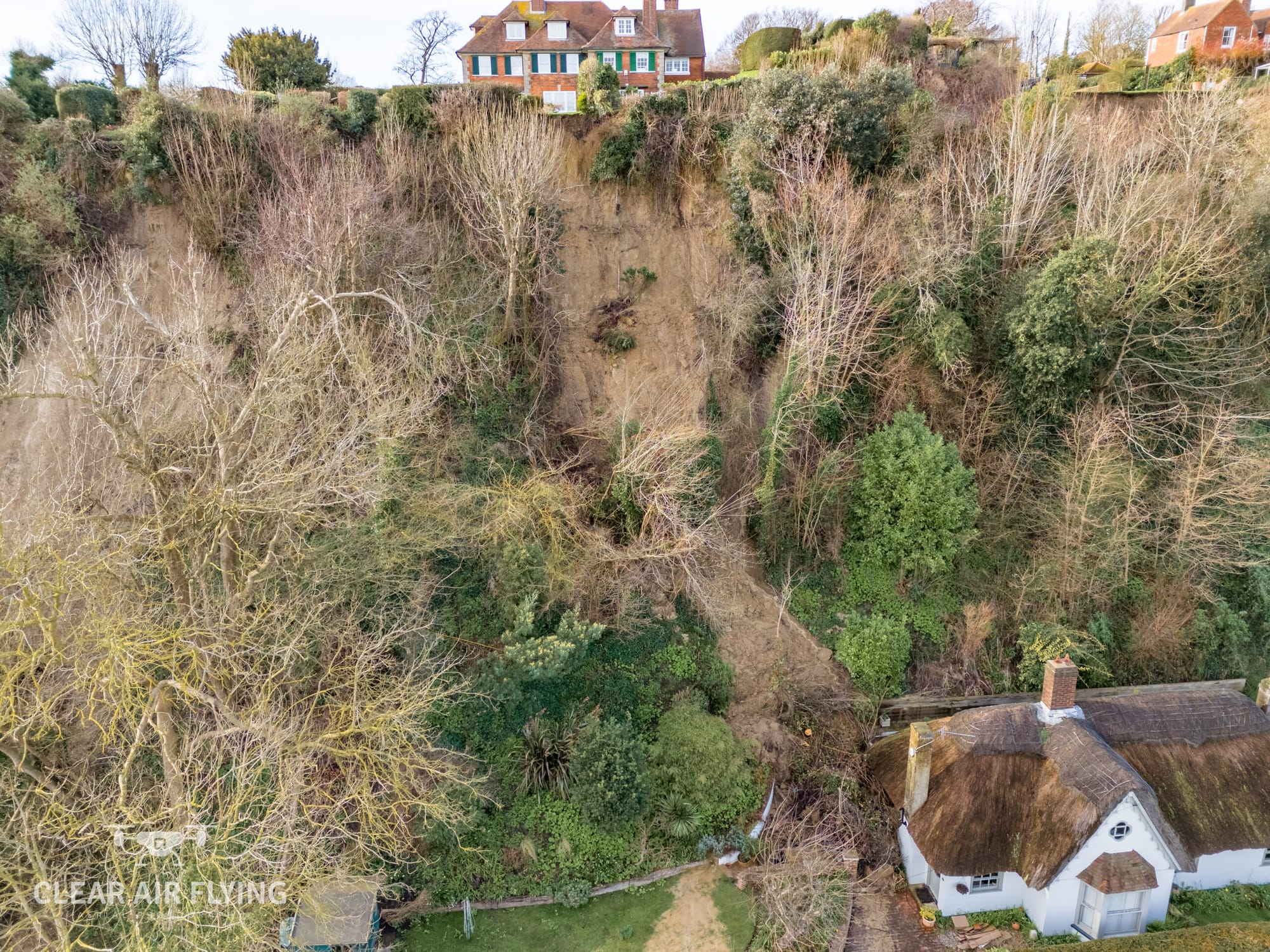
Rye has a long history of limited land slips. In recent years they have occurred on the north side of the Military Road, where there is escarpment and exposed sandstone, parts of the Citadel and Cadborough Cliff. Extreme rainfall penetrates the slope and loosens the surface so that it slides. Sometimes the removal of vegetation as part of groundworks by landowners can increase the risk. This has been covered separately here.
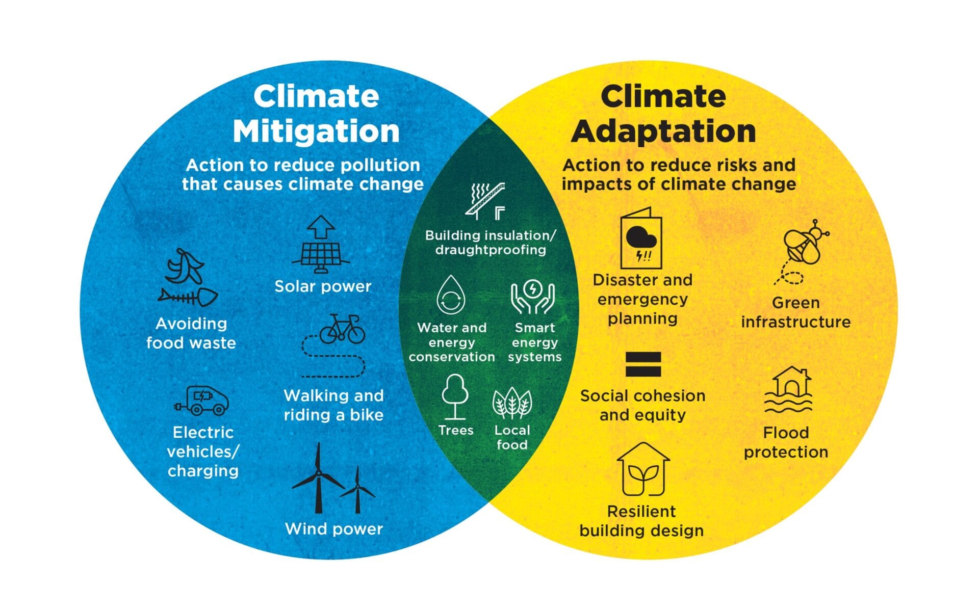
The future - mitigation and adaptation
The Environment Agency, drawing on Met Office data, works to understand flood risks and improve the assessments of flood and coastal risks. These assessments provide an understanding not just of the present-day risks but, by modelling, can predict future climate change impacts. The assessments drive strategies, such as mitigation and adaption. Both are well-documented, overlap and are complementary. When implemented, they help reduce global warming and tackle the impacts of climate change.
Mitigation aims to reduce the emissions and pollution that causes climate change, affecting the causes of flood risk. Measures include to: limit the emission of greenhouse gases into the atmosphere; adopt alternative power and travel systems; reduce power usage; conserve water.
Adaptation aims to reduce the impacts of climate change. Measures include to: increase green infrastructure to better absorb carbon; adopt natural flood management (measures to reduce flood risk in river catchment areas by planting and river profiling); manage storm water (retention basins and sustainable drainage systems - SuDS); ensure that there are emergency plans to handle critical events.
https://www.ryenews.org.uk/people/community/working-for-a-more-sustainable-rye
Tackling climate change is not just for experts. Everyone has to contribute by adapting and changing their domestic and behavioural lifestyles and their recreational and travel patterns.
With the present government focused onto development planning and growth, neighbourhood plans at town and parish level, remain an important way in which the community can influence developers and other authorities to seek a greener and safer environment.
Locally the reviewed Rye Neighbourhood Plan maximises sustainability, protection of the natural environment, and includes ways to tackle climate change.
In Rye, at the confluence of three rivers, tidal waters and the coast, it is an understatement to say that comprehending flood risk and the impacts of climate change is important. Flooding can be a disaster for those involved. Damage and displacement do not just have economic impacts but can seriously affect the mental health of those involved. Communities have to keep up to date with all the risks (current and future) and contribute to the work to reduce them.


