

How can we make it easier to cycle in and around Rye? Our town has huge potential for cycling, given that we’re mostly surrounded by flat land. We’re also fortunate that we’re on National Cycle Route 2 (NCN2), a long-distance coastal trail stretching 360 miles from Dover to St Austell.
The problem is that the current route through town goes up and down a set of steps and is mostly on roads which aren’t suitable for families, children or less confident cyclists.
Sustrans has recently re-surfaced some sections of NCN2 but more needs to be done. ESCC’s Local Cycling and Walking Infrastructure Plan (LCWIP) recommends a shared route from Monkbretton Bridge to Strand Quay via Rock Channel, which would provide a safer route through the town and improved connections to the east and west of Rye.
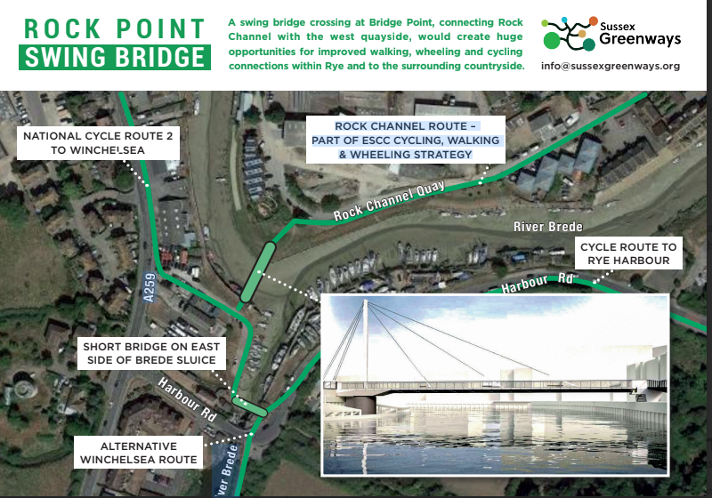
This route could be extended across the mouth of the Tillingham at Rock Point – not as a road bridge, but as a pedestrian, disabled and cycling bridge. A swing bridge wouldn’t hinder boat traffic to Strand Quay and would support the Rye Neighbourhood Plan by improving the town as a visitor destination, promoting green tourism, encouraging connectivity and sustainable transport, and fostering community health and wellbeing. It would also support the development of the King Charles III Coastal path – and the proposed housing on Rock Channel could provide funding.
Creating a new route through Rock Channel is the first step – please come along to discuss this and other ways to promote active travel in Rye on Wednesday, April 2 at 7pm in the Queen’s Head in Landgate. All welcome or contact: info@sussexgreenways.org


